Road Mapping Mission Creator
Instructions

Instructions
- Create a path along the centerline of a road. Accepable file formats and methods to do this include:
- A Google Earth Pro KML/KMZ file
- Use Google Earth Pro to navigate to the mission area.
- From the ribbon select the "Ruler" tool.
- In the Ruler tool, select the "Path" tab.
- Place points on the map corresponding to the centerline of a road.
- In the Ruler tool click on "Save".
- The New Path window will open. Click OK.
- In the "Places" window pane (on the left), right-click on "Path Measure" and "Save Place As" a KML/KMZ file.
- A DJI KMZ file
- Use Litchi's new Mission Hub to create a waypoint mission along the centerline of a road.
- Export the mission as a DJI KMZ file.
- A Litchi CSV file
- Use Litchi's Legacy Mission Hub to create a waypoint mission along the centerline of a road.
- Export the mission as a CSV file.
- A Google Earth Pro KML/KMZ file
- In page one of Road Mapping Mission Creator:
- Select the desired units.
- Specify whether the height should be above ground or above take-off.
- Select the mission height.
- Select the mission width. The mission will be created using three paths: the centerline mission plus paths on either side of this path.
- Use the file chooser to upload your input file.
- Select "Create Road Mapping Mission".
- In page two of Road Mapping Mission Creator for Litchi:
- Review (and understand) the parameters and calculations shown.
- Download the CSV file to your computer.
- In the Litchi Mission Hub
- Use the Missions menu to import the CSV file created by this web application.
- In "Settings" make sure that the following are set:
- Heading Mode should be set to "Custom(WD)".
- Path Mode can be set to either "Straight Lines" or "Curved Turn".
- Cruising Speed should be set to something comfortable like 8 mph (13 km/h).
- Depending on the drone, you may configure a time or distance interval on the first waypoint. If flying the mission using DJI Fly, this would have to be done manually when starting the mission.
- Save the mission.
- Preview the flight using Litchi's Google Earth simulation option
- It is recommended to preview and verify the flight using Virtual Litchi Mission.
- Fly the mission
- Set the camera to manual mode and adjust the exposure as desired.
- If flying this mission using DJI Fly, a photo distance or time interval will have to set configured manually to capture photos.
- Load the mission and fly.
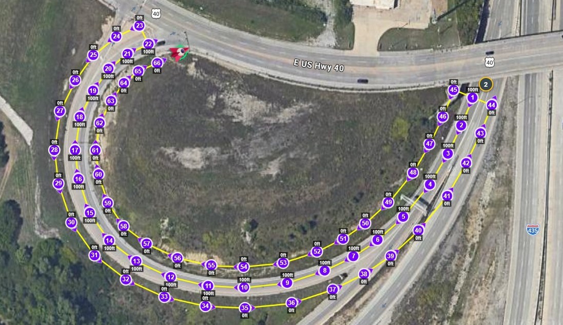
This application can be used to create a road mapping mission from a single path of waypoints representing the centerline of the road to be mapped. The centerline is expanded into three connected paths following the left, center, and right sides of the road. Headings are automatically calculated along each path. A distance interval is configured at the first waypoint to take photos at the specified intervals.
The input may be obtained from any of the sources listed below. Regardless of the source, only the GPS coordinates are used. Any headings, elevations, gimbal pitch angles, or other parameters contained in the input file is ignored.
- A CSV file from Litchi's Legacy Mission Hub containing two or more waypoints
- A Google Earth Pro KMZ/KML file containing one or more line segments
- A DJI Fly waypoint KMZ file exported from Litchi's new Mission Hub or directly from a drone